| |

|
|
| |
Last update: 04-21-2008
|
|
|
|
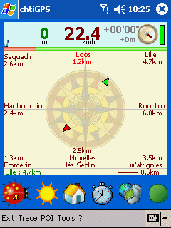
chtiGPS is intended to the sportsmen and to hikers, for their training (bicycle, rollers, ski...), but also to locate itself by knowing the distance and the direction from the closest cities. Geolocalization finally makes it possible to reassure its close relations at the time of great exits...
Available on PocketPC & Smartphone
GPS data on stringcourse (lat, long, alt, speed, direction, reception)
compass (small and large)
recording of layouts
statistics (average speed, distance, ...)
comparisons between various layouts (to be come)
sound tempo to ensure a constant train (to be come)
manage your training (race, bicycle, roller…) (to be come)
export to Carto Explorer (to be come)
recording of NMEA data in logfile
graphic interface and distance from the closest cities
choice a town of arrival to know the course to follow
Google Earth export (KML)
geolocalization via internet, find a friend: tezou
MovingMap
chtiGPS contains 7 country: France, Belgium, Switserland, Luxembourg, Netherlands, Germany and Great Britain.
|
|